Wednesday, November 08, 2006

Discovering Kuruwita

Kuruwita is a moderate sized town situated just about 10 km before reaching Ratnapura, if you’re travelling from Colombo. ‘Kuru Ganga’, which is the main tributary of the ‘Kalu Ganga’, with its origins at the Adams peak (Sri-pada) flows through this town; hence its name.

Many people consider Kuruwita as a route to Sri-pada (through Eratna) during the pilgrimage season or for its close proximity to the beautiful ‘Bopath Ella’ falls. It was same even with me until about 1½ years ago when I started discovering what a ‘package’ Kuruwita offers to a visitor.

Batadomba lena cave, Diva guhawa, Delgamuwa temple, Bopath falls and Dodan falls could be identified as main attractions in and around Kuruwita while all these locations could be reached during a days visit.

Let’s start off at Batadombalena which became an important archeological site after evidence related to pre-historic human activities were discovered. To reach the location, you should turn off at Ekneligoda on the Kuruwita - Erathna road and travel along the Siripagama road for about 3 - 4 kms. Get off at the Batadomba-lena junction and climb the hill on the left, trekking through the forest path for about 1 km. It’s worth to note that Siripagama is another route for pilgrims during the Sripada season. Batadomba lena consists of a few caves including a main cave which excavation is carried out from time to time. A visitor may be lucky to witness a little shower of water falling in front of the cave from the top if it’s a wet season. The road through the forest to the cave is a wonderful experience itself since it runs along a stream for a considerable distance.


Next stop is Divaguhawa. Come back to Ekneligoda and continue towards Eratna until you reach the Batathota junction. Take the road to the left for about 1 mile to reach the location which is now a temple known as ‘Batatota len viharaya’. This cave is big and spacious with some ancient constructions & drawings dating back to the Kandyan era. People believe this to be the cave which the Buddha visited on his journey to Sri-pada, although many wouldn’t agree with it. Adam's peak is clearly visible to this cave and it attracts a huge number of devotees during the Sri-pada season. If you are keen enough you may descend a bit further down from this main cave to the ‘Isthripura’ caves as well.

Back to Kuruwita and head towards avissawella for about ½ km. Go down the road in front of the Kuruwita post office for about 1 km to reach the ‘Delgamuwa Raja Maha Viharaya’. This temple is situated on an elevated land in close proximity to the Kuru ganga. The temple is said to have enshrined the sacred tooth relic of the Buddha during the kandyan era. The tooth relic was hidden within a huge quern made out of rock. This quern is to be seen even today.

I then reached the Higgashena bazaar and turned right to reach my next destination, ‘Bopath Ella’ falls. ‘Bopath’ means ‘Bo’ leaf in Sinhalese, which gives the falls its name since it cascades forming a similar shape. This is by far the most popular tourist attraction around Kuruwita and attracts many visitors during the weekend. Special care should be taken when bathing here as many have drowned in the recent past.
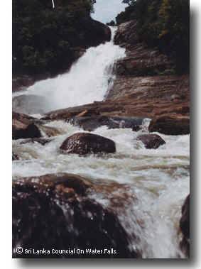


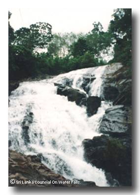
One might find it worthwhile to travel for about another 2 kilometers from Bopath Ella towards the Devipahala area, where the much unknown ‘Dodan Ella’ falls is situated. The fall is created by a tributary of the Kuru ganga which joins it near Bopath Ella. The topmost part of the fall descends to a deep pool where the water isn’t spilled over, but instead emerges underneath the rock and continues to cascade through to the second stage. This indeed is a strange and rare formation. A visitor has to descend down the waterfall along its edge to reach the bottom of the falls since no other path is available. Again prompt care should be taken when descending or climbing back up. The vicinity of the falls isn’t spacious as Bopath Ella but one could have a nice cool bath if interested.


Kuruwita offers more scenic and interesting places to visit apart from what I’ve mentioned here. Once the tour has completed, it’s just a maximum 2 hour drive back if you’re a visitor from Colombo.


Note: It’s very important that visitors behave responsibly while not causing damage to the environment at these places of visit.


Image sources:
http://www.srilankanwaterfalls.net
http://www.frontlineonnet.com/fl2112/stories/20040618003109700.htm

Thursday, October 05, 2006

Mini Hydro Power Projects causing destruction!

While the controversy & stubborn decision making revolving around Upper Kothmale continues, there is a similar or much bigger yet unnoticeable issue developing within Sri Lanka’s Environment-for-Power policy.

True that we are a tropical country with a lot of rain, (not to mention the severe droughts that are on the increase) but does it justify our current practices of utilizing natural resources for the country’s so called never ending ‘Power Crisis’?

What is a ‘Mini Hydro Power Plant’ (MHPP)?
  1. It’s relatively small in size & the amount of electricity generated. (usually a few Megawatts or a few hundred Kilowatts)
  2. It users water to operate its turbines.
  3. The water is brought down to the powerhouse from a little reservoir built above it. A big & long tube or tunnel is used for this purpose.
  4. The little dam which stores the water is built across a stream or a small river. Hence, the flow of water is interrupted and re-routed through the tunnel or tube towards the turbines of the powerhouse.
  5. Sometimes there are exceptions such as, the turbine/generator being situated within the tunnel itself. (Figure 2)
(Figure 1)

(Figure 2)


As you see the little contribution that the MHPPs make are only sufficient to fulfill the power needs of a few houses or a small village. That’s why you would normally find several MHPPs built in close proximity in a ‘chosen’ area.

So, what are the attributes of a ‘chosen’ area? These areas should have a considerable rain fall throughout the year with streams flowing with a sufficient amount of water. This means that these areas are more often than not rich in biodiversity and scenic beauty. Districts like Kegalle, Ratnapura, the Central province and a few other districts that experience a heavy annual rain fall are more often the candidates.

A dam built across a river may not appear to have a great impact in a rainy season, but when the dry season with less or no rain fall arrives, (at the moment it’s 3-4 months per year) what happens is that the stretch of the river from the dam to the water outlet goes dry. (See Figure 3) This leads to a river or stream with no water for that specific range and directly affects species fauna & flora, water springs and waterfalls.

(Figure 3)


Our experience has shown that this sort of ecological change takes place shortly after a few days of no rain in some areas where MHPPs have been built.

The construction, operation and management of MHPPs are done in several ways. In Kitulgala, we came across MHPPs which were built with aid from the Asian Development Bank. The maintenance is done privately while the people in the area must contribute a monthly levy for the maintenance of the MHPP and to payoff the debt received from these international monetary organizations as aid.

There is a different scenario in the Maliboda area in Deraniyagala where private companies are responsible for the construction and maintenance of MHPPs. They in turn sell/add the generated power to the main national grid while the government pays them back. These companies have found a large profit already by setting up MHPPs and destroying the forest in the process.

Some of the forest areas destroyed belongs to strict natural reserves as well. This is mainly done when constructing the dam, tube/tunnel and the powerhouse. Many beautiful waterfalls in and around Deraniyagala have already been threatened due to this behavior. Parties responsible for setting up MHPPs receive their required approval and consent through corrupted government officials and politicians in the area. They also make use of the ‘thirst’ of electricity the people in these areas face, hence misleading them of the dangerous long-term effects to come.

Long-term effects:
  • Extended draughts.
  • Landslides due to de-forestation.
  • Extinction of rare/endemic fauna & flora.
  • Drying out of springs & waterfalls.
An example of dangers caused to the environment is currently visible in Nekkawita/Deraniyagala, where a 10 MW (Megawatts) powerhouse is being constructed. A tunnel with a length of more than 1.5 km is being dug and a canal being constructed. Huge loads of earth have been dumped in the river where a dam is being constructed, making the river’s water brown and muddy, threatening its species. One wonders whether the 10 MW is worth the destruction being done to the environment.

If the volume of water is reduced as a long-term effect, no need to say that the productivity of these MHPPs would be greatly hampered and questioned in the future, making them worth nothing after all that destruction done to the ecosystem.

Clearly visible is the loose stance the government is taking and at times even promoting these projects so that they could wash their hands off it. Instead the government should take suitable & necessary measures in monitoring and approving these constructions while finding alternatives of providing electricity to the people in these areas.

Hopefully this sort of article enlightens many people who weren’t aware of it. Because though most of us enjoy the scenic beauty in our country, it’s only a handful that is aware of the dangers we face in protecting our environment for the future generation.


Image sources:
http://www.builditsolar.com